FETHIYE GUIDE
The city stands on the site of the Lycian Telmessus, whose beginnings to the 5th Century BC go back. According to recent research, this place was earlier, probably as early as the third Inhabited millennium BC. Telmessus formed together with the situated about 30 km north in the mountains near �z�ml� ruins Kadyanda the western boundary of the ancient Lycian Cities. Even at the time of Croesus Lyderk�nigs (mid 6th century BC) Telmessus was famous for its soothsayers throughout the eastern Mediterranean. In Byzantine times the city was called Anastasiopolis, later it was called Megry (Greek Makri).
In 1913 the city was renamed in honor of the perished in the vicinity of Damascus first Turkish military pilot Fethi of Megry in Fethiye. 1924 left the Greek residents under the Treaty of Lausanne, the area and settled in Greece, especially in the town of Nea Makri in East Attica.
Fethiye is the main shopping and supply center for the farmers of the fertile environment. From here there around the clock bus service to all major cities of the country (such as Istanbul, Ankara, Izmir and Antalya). Dalaman International Airport can be reached in about 45 minutes.
There are several industrial parks and hundreds of small workshops, but hardly any industry.
Tourism is the main industry. Most hotel resorts and 5 km, the longest beach (some sand, some gravel) are located in G�cek, a suburb of Fethiye.
The famous, situated in a bay with white sandy beach Oludeniz the turquoise blue sea is 14 km from the city center. At the eastern end of the bay surrounded by mountains, the Baba Dagi (Father Mountain) rises with its 1969 meters from the ocean. Fethiye itself offers only on the beach in G�cek swimming. The season extends over ten months.
The Old Turk and sometimes even ancient town, which was, despite numerous, sometimes severe earthquake still remarkably well preserved, was largely destroyed in the 1957 earthquake. In the middle of the 19th Century (before the devastating earthquake of 1856), the Hellenistic theater was found in good condition and described by the French scholar Charles Texier. Above the Eski Cami Mosque, the Old Town with its narrow winding streets and stairs as well as the typical corner houses still largely intact. In Fethiye, there are but a small museum nor a large, traditional hammam, which survived the earthquake.
Featured here are the Lycian rock tombs directly above the village in a steep rock face with the famous temple grave of Amyntas. At the ruins of the 15th Century by the Rhodian knights Hospitaller Order of St. John was built with the support of the Genoese castle is partially well to recognize that remains of a much older buildings were included. Re worth seeing are the ruins after excavation of the Hellenistic theater, which was up to the 1856 quake still quite well preserved. Stone blocks of the theater are rolled in the destruction caused by the earthquake to the approximately 70 m from the port and see in the shallow pool. The spilled theater was exposed in the second half of the 1990s, archaeologists from the University of Istanbul.
The wedge-shaped Fethiye level extends in a northeasterly direction to the approximately 25 km from Kemer on Esen Cayi (ancient name Xanthos), not to be confused with Kemer, Antalya. In the north, to the 2418 m high Boncuk massif is located. The highest elevation in the vicinity of Fethiye, the Uyluk Tepe, about 45 km east of the city reached 3024 m. Until the summer (June), you can see the snowy peaks of Calis the beach.
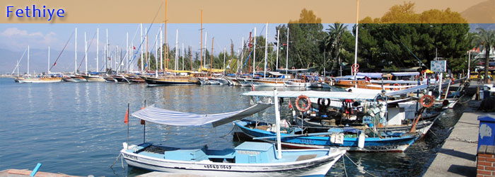
Lycian sarcophagus on a street in Fethiye Next to the harbor is a small business globetrotters like to overwinter used marina and several diving centers. From the promenade, which largely corresponds to that between the ancient conditioning, daily and weekly boat tours can be undertaken.
Are scattered over the central city still some Lycian and Roman Lycian sarcophagi in situ. (One is in a residential area even in the middle of a street Others are involved or used in the walls of the houses -. Tilted to the side - as chicken coops).
|
